Many people love Lexington’s older neighborhoods. Whether it be for their historical charm or walkability, they are highly desired leading to high property values, mainly due to their scarcity. You often hear that we “don’t build em like we used to”, and, to an extent, they are right. But what is often left unacknowledged is the fact that we’ve outlawed building those types of neighborhoods. Individually, rules about setbacks, lot size, frontage, coverage, and minimum parking don’t seem like they would have much impact. But together, they functionally outlaw historic forms of development. They prevent us from building new, compact, and walkable neighborhoods. Let’s dive into how exactly each of these rules forces large, spread out, car-dependent development.
Lot Size and Frontage
First, let’s look at the two things that dictate the size and shape of a lot. The most self-explanatory of these is lot size, it is simply the minimum size of the lot. This is usually in acres or square feet. In Lexington this is anywhere from 4,000 sqft to 25,000 sqft, but usually around 7,500 sqft for a residential lot. But this is just an area measurement and says nothing about the shape of the parcels. For that, you take into account minimum lot frontage. Frontage is the width of the parcel on the street side. In Lexington the minimum frontage requirements range from as high as 150 feet to 15 feet, but usually around 40-50 feet. So a minimum frontage and minimum lot size essentially dictate the minimum parcel size and shape. Let’s look at Lexington’s R-1C zone as an example. It has a minimum lot size of 8000 sqft and a minimum lot frontage of 60 feet. So, assuming a rectangular lot, that means the smallest lot in an R-1C zone is 60 feet by 133.33 feet.
Setbacks, Coverage, and Parking
Now that we know how to find the minimum lot size, let’s look at what affects the size and position of the building itself. There are numerous rules that can affect this but we will only be looking at the 3 main ones; setbacks, coverage, and off street parking.
Setbacks are the minimum distance required between the building and the property line. In Lexington, they are referred to as minimum front, side, and back yards. For front yards, it can vary from 10 to 60 feet, while side yards are anywhere from 3 to 10 feet. Backyards get a little weird because some zones require a minimum of 10 feet, while others require a proportion to the size of the lot, like 20% of the lot needs to be the back yard. Setbacks are the biggest thing that “push” new buildings apart.
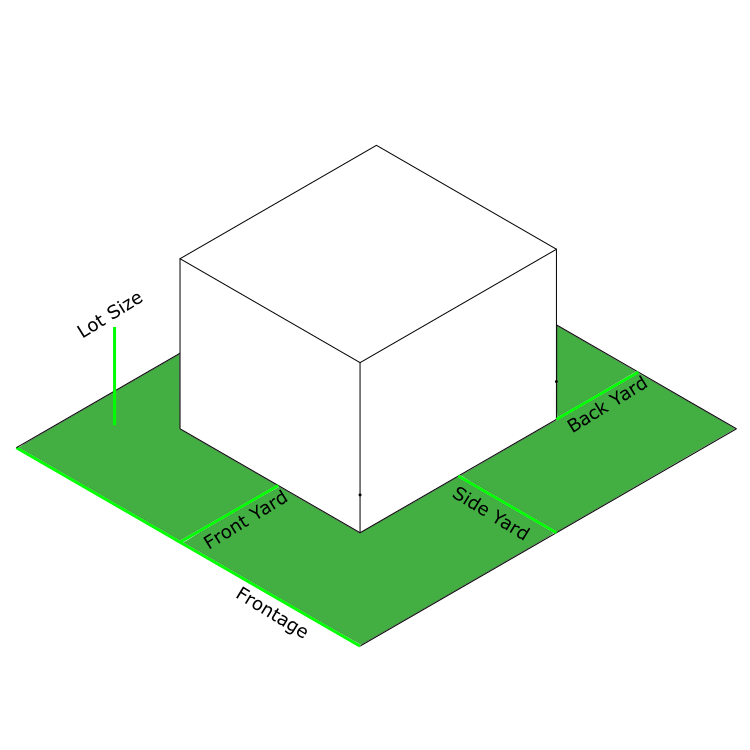
Maximum coverage refers to the maximum percentage of the lot that can be covered with a building. For an easy example, a 1000 sqft lot with a maximum coverage of 20% could only have a building footprint of 200 sqft. Note that this refers to the building footprint, not the whole building’s square footage. In our example we could have 2 200 sqft floors, for a total of 500 sqft of building. Low maximum coverage rules also push buildings apart because even if a proposed building is within the setbacks, it may be too large for the minimum coverage.
The last and somewhat counter intuitive regulation that affects the building size is off street parking requirements. This is the number of parking spots that must be on the property, complete with driveway and maneuvering area, i.e. a long driveway may be able to hold multiple cars, but only counts as 1 spot. These requirements are often setup based on either the number of residential units, number of bedrooms, square footage, or some really random things depending on the use. Daycares are based on the number of kids, while churches are based on the number of seats. This has a big effect on what gets built because land that’s taken up by parking is not land that can be used for a building. And parking garages are incredibly expensive, with prices around $15,000 per spot, so they really only make sense for large developments.
Illegal Neighborhoods
All of these regulations hamper development on small parcels or simply prevent building things closer together, and proximity makes walkability. What many people don’t realize is that these rules make it illegal to build neighborhoods similar to our older, most desired neighborhoods. Neighborhoods like Woodward Heights, South Hill, Gratz Park, and Northside, to Aylesford, Chevy Chase, and Kenwick, would all be impossible to build today with our current zoning ordinance. Let’s take a look at some examples and what makes them illegal.
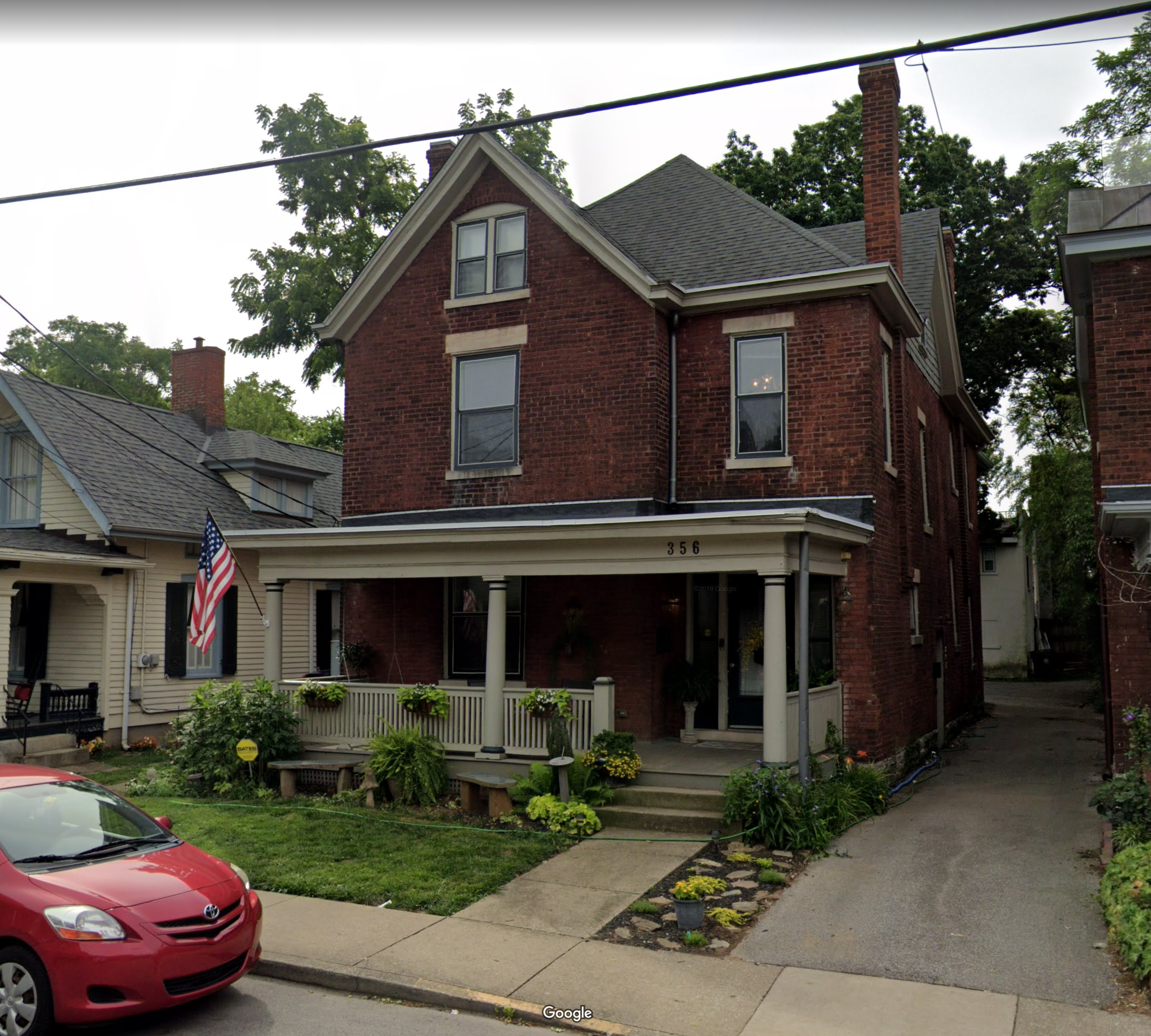
This is 356 South Upper Street. According to the PVA, it is zoned R-2 Two-Family Residential. While it is zoned for two family, it appears to be a single family household, so the parking is not an issue. But everything else is. The total lot size is 5445 sqft, when zoning requires 7500. The frontage is only 36.5 feet, when zoning requires 60 feet. I can’t be certain on the exact measurement of the front yard, but it certainly isn’t the required 30 feet. The same can be said for the side yard, those houses obviously are not 12 feet (6 foot side yards each) apart. Let’s go to the other side of downtown, but stay on Upper Street.
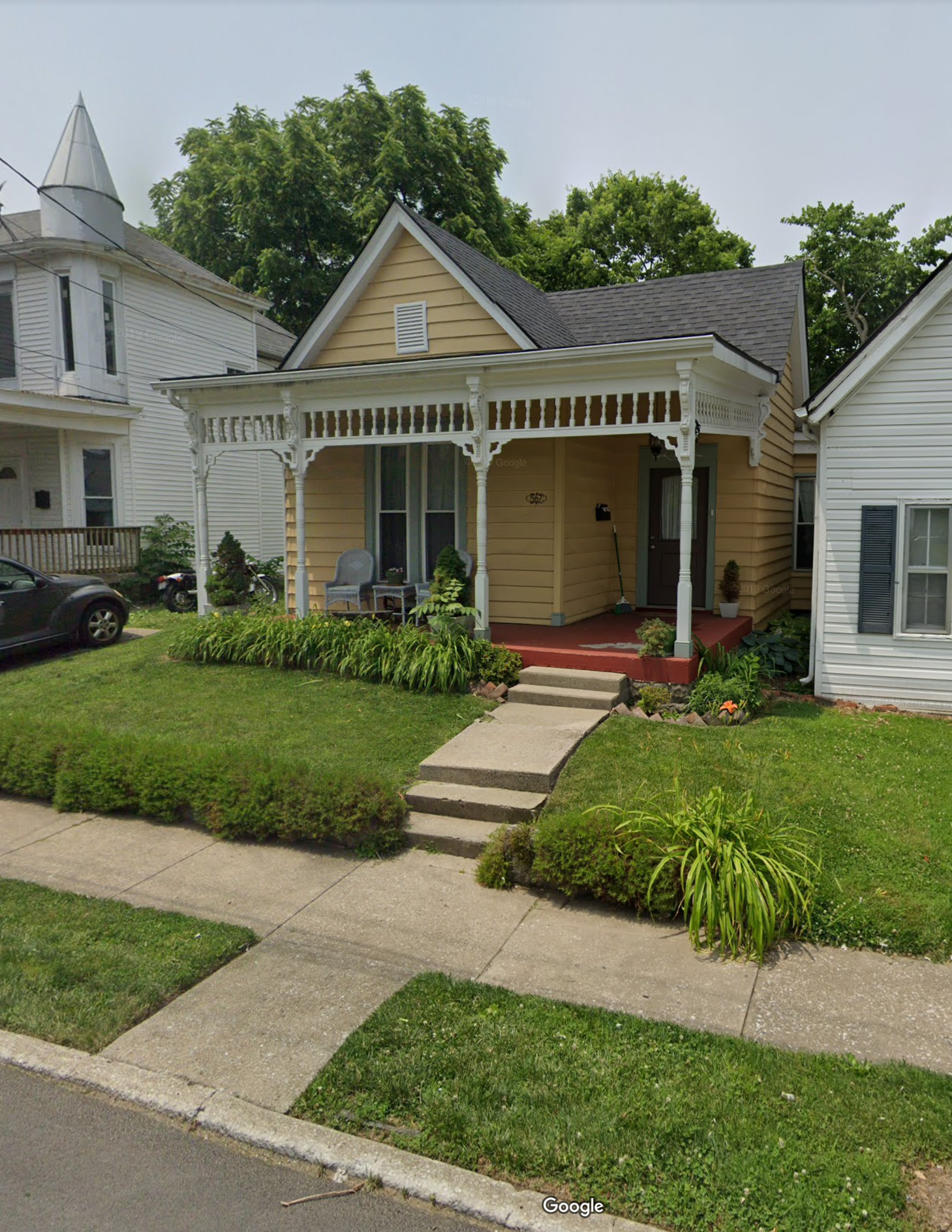
This adorable cottage is 569 North Upper Street. According to the PVA, it is zoned R-3 Planned Neighborhood Residential, and also appears to be a single household. And it’s the same story for the numbers; lot size of 2610 sqft when 6000 sqft are required, frontage of 30 feet when 50 is required, front yard is definitely not the required 20 feet, and it has no off street parking. Nothing about this property is zoning compliant.
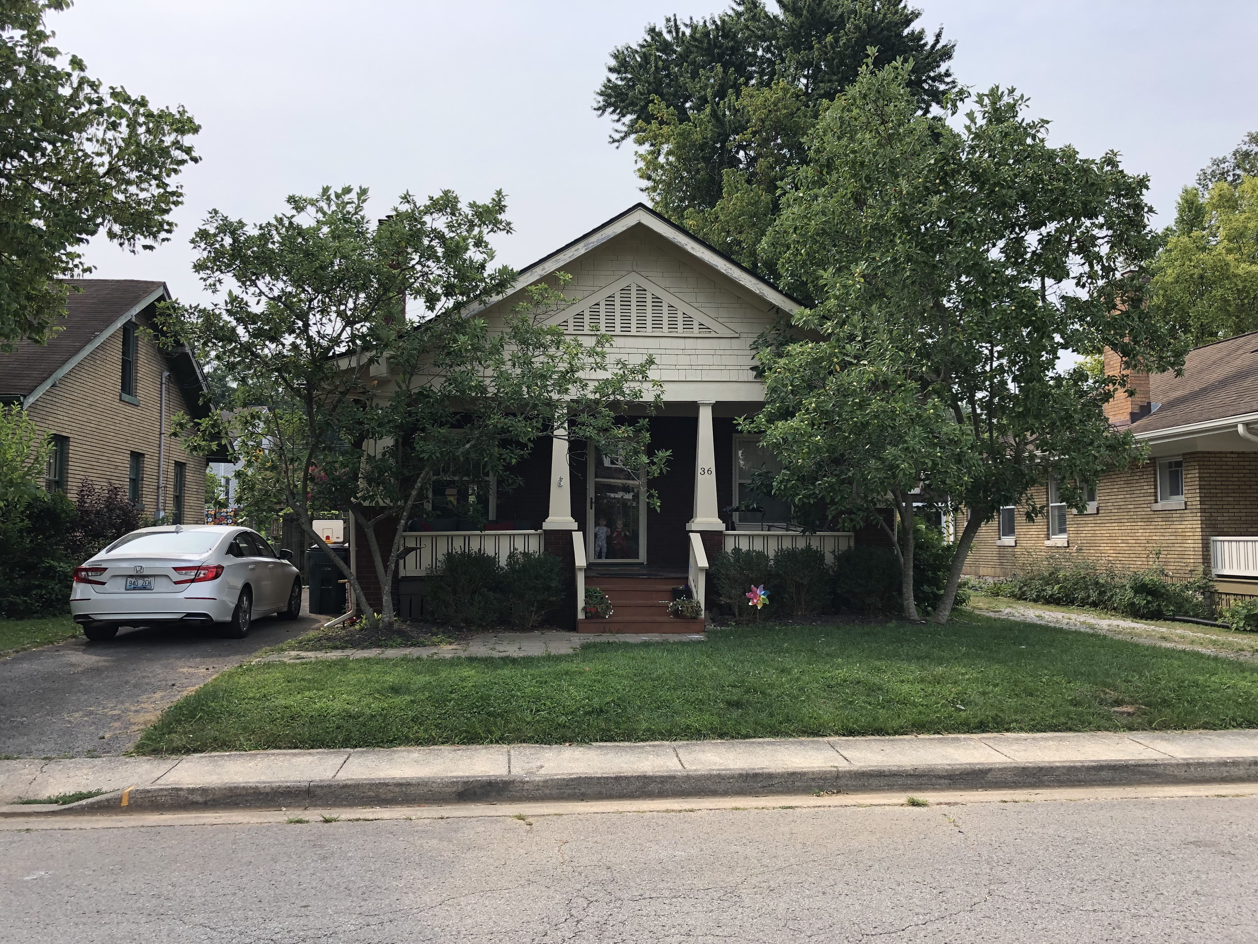
This is my house, 36 Richmond Avenue, here in the Kenwick Neighborhood. It’s a typical mail order Craftsman bungalow from the 1920s. We are also zoned R-2, but it’s only a single family house. The whole lot is 5400 sqft with a frontage of 45 feet. Yet again, completely illegal to build today. You would be able to build my house, or any of these other examples and their neighbors, but they would have to be on much larger lots, taking up a lot more land, and being much farther apart. All which hurts the walkability that we love of our neighborhood. A 10 foot longer front yard can be the difference between talking to your neighbors from your front porch as they walk by and just waving if they even notice you.
So we have all these older neighborhoods that you couldn’t emulate today in any new development. You might be able to build the housing type or style, but it would be at much lower densities and significantly less walkable. Why is that the case? Why have we essentially outlawed walkability? The neighborhoods being small and compact doesn’t cause any problems for them. They are some of the most desired neighborhoods in Lexington, with the property values to prove it. It doesn’t seem like there is much impact when you look at a single property. What’s the difference in making the lot 10 feet wider? But it’s a compounding problem. 10 extra feet per lot adds up quickly. 40 extra feet and you’ve lost a whole potential house for what is essentially wasted space. This is just another way in which our current zoning ordinance is resulting in worse development today, and it’s something we should change. In my next post, I’m going to show what would be the result if you tried to make a new Kenwick, but to today’s zoning requirements.